Op Sindoor: IAF Achieved its Aim and Validated Weapon Systems
- July 28, 2025
- Posted by: Col Vinayak Bhat (Retd)
- Categories: India, Pakistan
No Comments
Author: Colonel Vinayak Bhat (Retd)
Keywords: Operation Sindoor, Air Defence (AD), IAF, PAF, IACCS, Attacks
Introduction
Operation Sindoor has proven to be another feather in India’s cap after the Balakot strikes in February 2019. India’s Air Defence (AD) and the Indian Air Force demonstrated their professional acumen and technological prowess, with the Indian Navy and Army playing a decisive and supportive role.
The planning for Op Sindoor was initiated following the unrestricted authorisation to use air power. Comprehensive intelligence was gathered regarding the status of terrorists at 21 identified locations. Ultimately, only nine of these locations were selected based on specific information indicating the presence of terrorists. Preparations were made for a plan to dismantle terrorist infrastructure in Pakistan and Pakistan-occupied Kashmir (PoK). The plan included various contingencies following an escalatory ladder disproportionate to Pakistan’s actions in a carefully coordinated use India’s air power.
Some members of the Indian media had started to question the preparedness of Indian forces, showing a lack of understanding regarding the complexities involved in preparing for military conflict with a determined, nuclear-armed, and religiously motivated adversary. One commentator even suggested, “India could stop short of an escalatory military assault similar to the Balakot air strike of 2019.” [1] Everyone thought Jabba Top attack was the highest point of India and any such strikes would breach the nuclear threshold for Pakistan and India was unlikely to take military measures and would be content with only abrogating the Indus Waters Treaty (IWT).
Precisely 14 days after the terrorist attack, the Indian government passed orders to all states to practice civil defence and blackouts on the evening of May 07, 2025. Blinded by the love for their terrorists, the adversary could never have assessed or even guessed the D-Day for Indian forces to be the same.
Pakistan tried in vain to clarify its position with regards to the Indian strikes on May 07, 2025, following a call from the Indian DGMO (Director General of Military Operations) to explain that India’s fight was against terrorist activities targeting innocent tourists and that no civilian, military, or intelligence infrastructure was attacked.
Pakistan military and intelligence nexus which had become a collusive, all powerful front, superior to the Pakistani government, decided to attack Indian military installations and air bases in response to the Indian strike on terrorist infrastructure/ camps on May 07, 2025. They even dared to attack India with ballistic missiles creating a nuclear bogey but in vain. All Pakistani attacks, big or small were thwarted with professionalism keeping our men safe and systems operationally ready.

Source: Maxar Technologies
IAF’s perfect and accurate attacks on Nur Khan and Murid Air Bases’ C2 AD (Command and Control, Active Duty) facilities [2] rendered Pakistan Air Force’s capability to launch any air operations untenable bringing Pakistan to its knees.
This paper looks at Op Sindoor through the kaleidoscope of satellite imagery to explain India’s intent of lauching escalatory strikes to achieve its aim.
Revisiting Balakot
Pakistan has typically obfuscated evidence whenever it has been presented, especially in the form of dossiers. When the Pulwama attack happened, India decided to attack one of the terrorists’ training camps, masquerading as a madrassa.

Source: Google Earth and Internet
On February 26, 2019, the attack on Jaba Top took the PAF by surprise. The Indian Air Force (IAF), for the first time after the 1971 war, had crossed the International Boundary (IB) to hit a target inside Pakistan. Even before India announced it, Pakistan’s Director General ISPR (Inter-Services Public Relations) had already tweeted about the attack. The aim of the early and quick tweets by DG ISPR was to ensure that India did not deny crossing the IB. However, on the contrary, India claimed the attack across the IB within minutes.
The Pakistan Army, which excels in cleaning operations, was more than ready that day. It ensured a cleanup and minor repairs before 10 am so that satellites wouldn’t be able to notice anything unusual.

Source: Google Earth and Digital Globe
However, a lot was observed on satellite images despite Pakistan Army’s efforts to hide the damages. The peculiar small holes of SPICE 2000 were covered up in no time but the job obviously was done very unprofessionally leaving behind telltale signs.
The Corrugated Galvanised Iron (CGI) sheets are very pliable and have a tendency to try to regain their original shape. The penetrating power of the SPICE 2000 missiles is so strong at those high speeds (>Mach 2) that the holes created in CGI sheets look much smaller than even the size of the missile on satellite imagery. This makes it difficult for an untrained eye to believe if any attack had taken place.

Source: Google Earth
The change in CGI sheets is visible in the images of Google Earth dated February 27, 2019, which is not a particularly difficult thing to do. The comparison of before and after images provides more clarity on the changes to the CGI sheets that occurred after the IAF attack.

Source: Maxar Technologies
A similar comparison with images from Op Sindoor illustrates how challenging it is for an untrained eye to discern from satellite imagery that the IAF has indeed hit buildings, unless ground photos are made available. The size of the impact point is tiny (less than a meter), which is barely equal to two or three pixels on the satellite image with a 30 cm resolution.

Source: Via Internet
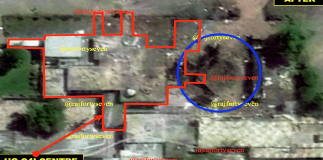
The buildings in the Muridke headquarters of Lashkar-e-Taiba (LeT) were hit with precision and possibly with similar weapons used during the Balakot strike. This time, the cleaning operation by the Pakistan Army and Inter-Services Intelligence (ISI) was caught on satellite images.

Source: Maxar Technologies
The second building at Muridke, located next to the hospital, was used by terrorists as a storage facility for their small arms and was destroyed. However, the changes visible in satellite imagery were quite subtle, even to a trained eye. The distorted walls and roof suggest that the building had collapsed, and the dome had fallen below ground level.
